


As cities across Africa experience rapid growth and increased demand for mobility, there is an urgent need to transition towards more sustainable and effective urban transport systems. The urban planning decisions made today will shape cities for decades. However, improvements require a solid understanding of existing transport networks, coverage and accessibility gaps, and opportunities. These tasks are particularly complicated in the context of the large number of “paratransit,” semi-private transport operators, which provide a mosaic of overlapping and intermittent services in most African cities and are most people’s primary option for getting around.
A recent project co-led by Transport for Cairo and WRI’s Digital Transport for Africa, with funding from the French Development Agency, demonstrates how mapping and digitalization of transit data can provide city decision-makers with actionable insights into shaping the future of their transport networks, even amidst the complex environment of many operators and little centralization or comprehensive route maps.
The project developed a model of targeted data collection and skills training that can empower cities to lay the groundwork for data-driven transportation planning. We undertook a full-scale data collection and analysis initiative in Alexandria and “beyond mapping” initiatives in Kumasi and Maputo to help the cities extend the impact and benefits of previous mapping efforts.
Building a Foundation in Kumasi
While enthusiasm for digital transport tools exists in many cities, priority is often given to developing new, large infrastructure projects as opposed to better understanding existing networks to plan for improvements that can increase the efficiency of available services. As well, decision-makers often do not have the right kind of data that can provide insights into their process. Even when useful datasets are available, cities may lack the expertise to fully leverage them for analysis and planning.
In Ghana, a close collaboration with Kumasi Metropolitan Assembly’s Department of Transport revealed a strong desire to utilize existing transit data to digitalize and improve management of the city’s trotro minibus network. The city of more than 3.5 million has some transit data from a bus rapid transit (BRT) feasibility study conducted in 2020. WRI and Transport for Cairo helped deliver the outputs of the previous data collection project in a standard General Transit Feed Specification (GTFS) format and worked to integrate the dataset into the transit mapping system used by the Department of Transport to manage and regulate trotros. This process involved extensive cleaning and reformatting of data from the previous study.
To enable sustainable management of the transit data, the project also provided hands-on training to city officials and students from Kwame Nkrumah University of Science and Technology on best practices for transit data collection and utilization. The training sessions provided knowledge and capacity for the institutions to conduct data collection and updating projects themselves in the future.
Moving forward, fully integrating ongoing data collection activities into long-term operations is a real opportunity for the city. But maintaining frequently updated datasets requires commitments of staff time and budget. Participatory processes incorporating rider feedback into route design and accessibility considerations also require resources but will help ensure that data translates into better service. There will be opportunities to leverage the outcomes and insights of this work for future endeavors, including the $440-million Kumasi Urban Mobility and Accessibility Project (KUMAP), led by the World Bank.
Leveraging Data to Inform Integration in Maputo
Using a comprehensive urban transport master plan developed by the Japan International Cooperation Agency in 2015, Maputo, Mozambique, is aiming to transition from an ungoverned, low-capacity paratransit network to a system of mass transit modes, including BRT, and professionalization of existing services.
WRI and Transport for Cairo partnered with the Mobility and Transport Observatory, a non-profit monitoring and research organization, which has already mapped Maputo’s central paratransit network of chapas minibuses and plans to map more areas in the Maputo metropolitan area soon. Together, we worked to deliver targeted improvements to fill geographic and temporal data gaps.
To demonstrate the power of more robust data, we conducted a sample analysis of paratransit routes that would overlap with proposed BRT corridors. This exercise revealed that almost 50% of existing chapas routes overlap geographically with the proposed BRT corridors in a significant way, making them potential competitors. This also means the workforce of the overlapping routes and surrounding commercial activities serving them will be affected.
As Maputo moves forward with plans to professionalize transit and integrate new BRT services, sustaining participation from these operators will be critical. Continued mapping by local data partners can help redesign existing routes to avoid overlap and act as feeders to the new system, serve latent demand in emerging neighborhoods, and establish standards for transit accessibility, enhancing reliability and safety.
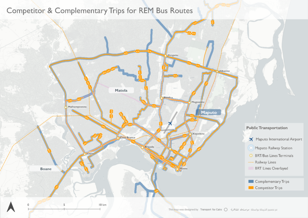
This exercise showed how data can help inform inclusive transport planning by accurately modelling paratransit services and integrating them into a unified model with scheduled services, such as the new BRT.
We also undertook virtual capacity building training sessions to enhance the Mobility and Transport Observatory’s proficiency in data collection efforts and leveraging the results. The adoption of improved data collection and mapping methodologies for upcoming projects promises to provide an increasingly comprehensive understanding of regional transit networks.
Empowering Young Leaders in Alexandria
Today Alexandria, Egypt, is witnessing two major transport investment projects: construction of the Abu Qir Metro along the city’s eastern coast and the rehabilitation of the Raml Tram. But these projects will soon cause suspension of operations that traditionally transport hundreds of thousands of passengers every day. More people than ever will be reliant on the city’s formal and informal bus networks instead, but the city has little to no digital data on them.
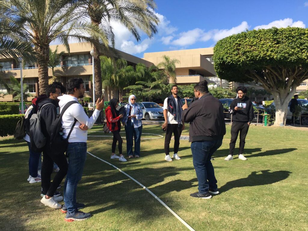
WRI and Transport for Cairo collaborated with the UPGRADE+ program at the Arab Academy for Science and Technology to initiate a data collection and mapping project. The project engaged 80 students to collect data on public transport routes. With hands-on training sessions on field research techniques and data analysis, the project gave young Alexandrians firsthand experience collecting and leveraging transit data to better understand how their city moves.
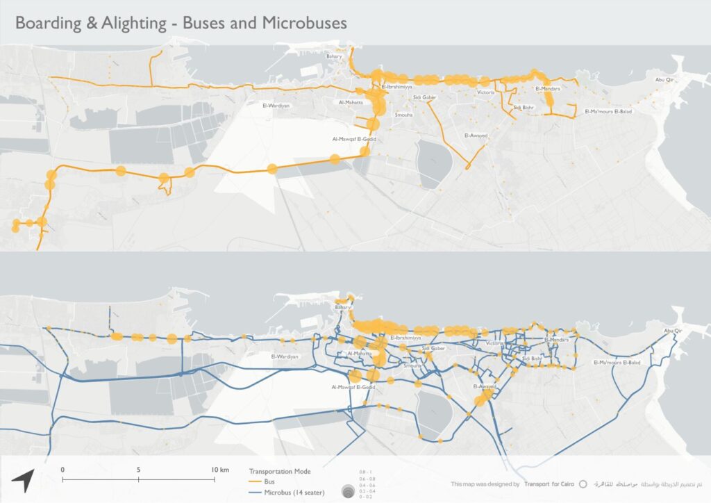
The resulting GTFS data outlines the city’s sprawling bus networks in fine detail, documenting over 500 distinct routes. Furthermore, preliminary insights about the network were generated from analyses on boarding and alighting patterns, commercial speeds of different modes, and network coverage.
This collaboration has produced a significantly better understanding of the city’s bus networks, both formal and informal. But sustaining Alexandria’s data capacity will require continued nurturing of data literacy among the city’s next generation, through the Academy or other university partners. Partnership with transit agencies and businesses are another opportunity. Building recognition of the value of open data and participation in skills exchange and open mapping initiatives can improve the coverage and value of the data for all.
Mapping a Path Towards Equity and Sustainability
Across all three project cities, intensive engagement revealed the possibilities and pitfalls of open transit data to help make sense of dynamic paratransit networks. While route, coverage and other data is essential for 21st century transport planning, it does not exist in a vacuum. Technical mapping and monitoring capacity must be met with institutional leadership, funding commitments and participatory processes for translating data into actionable insights.
Decision-makers and local institutions can draw key lessons from this project for their unique contexts, from leveraging existing datasets and generating insights for decision-making, to fostering continuous capacity building for mapping initiatives, instituting open data sharing policies, funding ongoing data collection and analysis initiatives as standard practice, engaging citizens, schools and universities in participatory data initiatives, and utilizing insights to guide inclusive planning of transit infrastructure.
Even though full-scale data collection and mapping projects can be costly, there are simple and easy-to-implement methods using open tools to help cities transition away from manual and static data collection and management systems. DT4A offers a wealth of essential resources, including tools for data collection, analysis and management, along with valuable best practice experiences.
For funders and international partners, sustained engagement and financing is vital to develop local data ecosystems. Support should focus on facilitating collaboration and skills transfer to local actors, whether municipal authorities, academia or civil society. Emphasizing the creation of high-quality datasets with sustainability and ownership components is essential to ensuring acceptance and enabling cities to leverage limited resources effectively. Furthermore, integrating data components into large infrastructure projects such as traffic management, BRT and road rehabilitation efforts can greatly improve results.
The path to realizing sustainable and equitable transport begins with cities’ commitment to understanding their transit systems and how to better serve residents’ mobility needs. Mapping existing networks, quantifying current usage and engaging all stakeholders in the process to both improve efficiency and accessibility is essential. Only by coming together around a shared understanding of their city’s transportation landscape will stakeholders gain the clarity needed to chart a more inclusive path forward.
Abdelrahman Melegy is Head of Transport for Cairo’s Data Lab.
Agraw Ali is Senior GIS Research Associate for WRI Africa.

