

Posts tagged with 'Google Maps'

What do you think of when you hear the word “slum”? For many, the word brings to mind poverty, violence and squalor; slums, or informal settlements, are overwhelmingly associated with the negative. This is particularly true in Rio de Janeiro, ...


On the heels of Google recently releasing its new version of Google Maps – complete with contextual information based on past Google searches, different transport options with real-time traffic notifications, and panoramic photo tours – it’s hard to remember what ...

Welcome to Mapping Mobility, our recurring series on innovative cartography in the public space. We’ll highlight innovation and stories about the conceptual urban space and how we navigate it with humanity’s most essential mobility tool. The recent release of Apple’s severely flawed iOS 6 ...
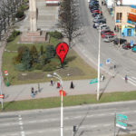
German artist Aram Bartholl has installed physical versions of Google Map’s red place markers in the middle of cities around the world. The urban art installation, “Map,” is meant to question the boundaries between the physical environment, the digital world and censorship. ...
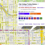
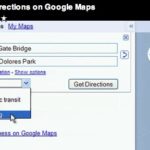
I almost cried the day that Washington, D.C.’s Metro and Google announced that users could use Google Maps to plan their trips on the D.C. area public transit system. Today Google announces even bigger news for all Google Transit users: ...
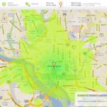
Want to know how far you can travel using public transit under 15 minutes? There’s a map for that! Stefan Wehrmeyer, a Berlin-based software architect developed a tool that uses public transit data to help users decide on where to ...
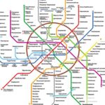
Moscow just released its new metro map. We thought it would be interesting to write about the most well-designed maps of various cities’ public transit systems. Moscow’s new map took four years to develop, according to the design firm behind it, Art. ...
Google Maps now has directions for cyclists! In 2005, Google started offering directions for car drivers, then two years later, it added transit routes. The map navigation expanded to pedestrians in 2008. We’ve already written about how Google Maps is ...

Considering a company whose mission is to “to organize the world’s information and make it universally accessible and useful,” I think it’s safe to say that Google’s map division has met and exceeded all expectations when it comes to deploying ...
Giant potholes on your route to work? Obstructed views of oncoming traffic? Broken sewer grate? Report these and other non-emergency issues to SeeClickFix.com, a free social networking and online mapping tool (powered by Google Maps) that “provides technology to empower ...

