

Posts tagged with 'urban mapping'
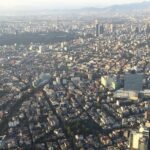
Remote sensing has revolutionized how we measure and understand the Earth. We can now track deforestation across the globe, predict end-of-season crop yields and identify wildfires in near real-time. But exploration into its possibilities for urban areas has only just begun. ...

Throughout the COVID-19 pandemic, we have been told to stay at home, stay close to our neighborhoods and try to enjoy being outside. But what if there is no park nearby? What if your home is tiny with no outdoor ...
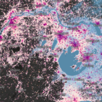
Among cities with the highest rates of outward expansion are coastal cities that are extremely vulnerable to flooding from sea level rise and storm surges. Map by Resource Watch Urban expansion and sea level rise are combining to increase the ...
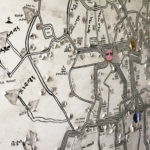
Hand-drawn in black marker and spanning an entire wall of Addis Ababa’s Anbessa company headquarters is a map depicting stops, timetables and fares for the city’s 73-year-old public bus system. Peeling icons and stickers tell a history of corrections and ...
TheCityFix discovered what quite possibly could be the world’s coolest transport-related master’s thesis project-recap video. The recent debut of the BRT in Action Newsletter, published by Santiago, Chile’s Centre of Excellence for Bus Rapid Transit, included a link to Jay ...

Welcome to Mapping Mobility, our recurring series on innovative cartography in the public space. We’ll highlight innovation and stories about the conceptual urban space and how we navigate it with humanity’s most essential mobility tool. The recent release of Apple’s severely flawed iOS 6 ...

