

Posts tagged with 'online mapping'
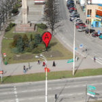
German artist Aram Bartholl has installed physical versions of Google Map’s red place markers in the middle of cities around the world. The urban art installation, “Map,” is meant to question the boundaries between the physical environment, the digital world and censorship. ...

The Mobility Lab, a project by the Arlington County Commuter Services, is hosting the Transit Hack Day on Saturday, September 10 for developers, mappers and transit data enthusiasts in the Washington, D.C. metro area. Transit Hack Day provides a space ...
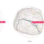
Xiaoji Chen, a graduate of the Massachusetts Institute of Technology, created isochronic maps of Paris and Singapore that represent distance on a map proportionally to travel time. The distorted maps show that the distance between any two stops in a city ...

Escuelab, Softwin, Social Media Group and Development Seed are hosting an Open Data event in Lima, Peru Saturday, August 13, 2011. The event, “Open Data Meetup Lima,” is a day of sharing ideas, activities and workshops related to open data ...
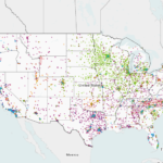
Today, the U.S. Department of Energy released an interactive map displaying thousands of alternative fuel stations around the nation, as part of a complete overhaul of Energy.gov. Color-coded points represent various alternative fuel sources, including electric and hydrogen stations. In ...
Via the blog, SupraGeography, written by Oliver O’Brien, a researcher and software developer at the Centre for Advanced Spatial Analysis (CASA), TheCityFix came across wheelmap.org. It’s a website (and iPhone app) built to display and aggregate information on wheelchair access in ...

Women in cities all over the world bear the burden of constantly having to strategize in order to remain safe, comfortable and secure in the face of sexual harassment by men on overcrowded public transport. Depending on their profession, geography and ...

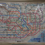
Moscow just released its new metro map. We thought it would be interesting to write about the most well-designed maps of various cities’ public transit systems. Moscow’s new map took four years to develop, according to the design firm behind it, Art. ...

Who doesn’t love a little friendly competition? The National Resources Defense Council (NRDC) this month launched Smarter Cities, a multimedia Web site and interactive mapping tool that shows how U.S. cities stack up against each other across several indicators of ...

